 |
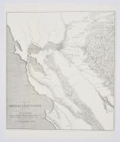
Small historically significant California Gold Rush map titled "Sketch of General Riley's Route through the Mining Districts". Historical Context The Creator: The map was originally sketched by Lt. George Horatio Derby of the U.S. Army Corps of Topographical Engineers. It was copied by John McHenry Hollingsworth and published in 1850.The Mission: It documents the official 1849 reconnaissance tour of Brigadier General Bennet Riley, the last military governor of California, during the chaotic early days of the Gold Rush.The Goal: The military group traveled across the central valley to survey strategic logistics routes, map out temporary settlements, and locate sites for army posts to keep the peace between gold prospectors and native populations.Cartographic Significance First Mentions: This document is highly prized by historians because it labels several iconic Sierra foothill mining camps for the very first time on a printed map.Historical Locations: It documents early locations like Coloma (spelled "Colluma"), Mormon Island (spelled "Mormont"), Sonora ("Sororam Camp"), Jamestown, Angel's Camp, and Woods Creek.Daily Tracking: The map tracks the exact route day-by-day with timeline markers from July 10 to August 20, 1849, charting their movement from Monterey up through San Francisco and into the major central valley river branches. |
|
|
