 |
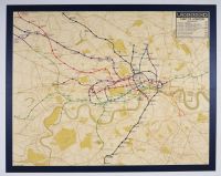
40 x 50, royal quad, This is an historical London Underground map, likely from the early 20th century, before the now-iconic diagrammatic style was adopted
. This map is a geographical representation, meaning it attempts to show the train lines in their actual locations relative to the city streets and the River Thames.
This "geographical" style was used for the earliest London Underground maps, which were first produced in the 1860s and 1870s and became a single system-wide map in 1908. This design style had limitations, as the crowded central London area was difficult to read as the network expanded. This led to the development of a more simplified, diagrammatic map by Harry Beck in 1931, which was first published in 1933.
Based on the style and the lines shown, the map appears to be from a period around the 1910s to the 1920s. This is distinct from Beck's revolutionary design, which was based on electrical circuit diagrams and disregarded geographical accuracy in favor of clarity and readability |
|
|
