 |
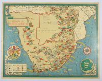
Attraction size, Map poster vintage illustrated map of the Union of South Africa by the notable British artist and cartographer MacDonald Gill. The map was originally published as a poster by the Empire Marketing Board between 1927 and 1933 to promote South African products and fisheries.
Map Details and Features
Purpose: The map was created for propaganda and promotion, highlighting the Union's agricultural and industrial resources. A text box on a similar map mentions it shows how the country's industry helped the United Nations war effort, particularly during the 1940s.
Illustrations: It is a pictorial map, featuring detailed illustrations and annotations of:
Agriculture and Farming: Sheep, cattle, oranges, wheat, tobacco, and sugarcane.
Mining: Icons for gold, diamonds, coal, iron, copper, uranium, platinum, and magnesium.
Geography: Mountains, rivers, and ships at sea, along with a compass rose and the coat of arms.
Political Context: The map depicts the political divisions of its era, including the Bechuanaland Protectorate (which became the Republic of Botswana in 1966) and the four provinces of the Union: Cape Province, Natal Province, Orange Free State, and Transvaal Province. |
|
|
