
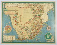
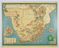
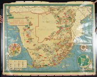
Union Of South Africa
Attraction size, Map poster vintage illustrated map of the Union of South Africa by the notable British artist and cartographer MacDonald Gill. The map was originally published as a poster by the Empire Marketing Board between 1927 and 1933 to promote South African products and fisheries.
Map Details and Features
Purpose: The map was created for propaganda and promotion, highlighting the Union's agricultural and industrial resources. A text box on a similar map mentions it shows how the country's industry helped the United Nations war effort, particularly during the 1940s.
Illustrations: It is a pictorial map, featuring detailed illustrations and annotations of:
Agriculture and Farming: Sheep, cattle, oranges, wheat, tobacco, and sugarcane.
Mining: Icons for gold, diamonds, coal, iron, copper, uranium, platinum, and magnesium.
Geography: Mountains, rivers, and ships at sea, along with a compass rose and the coat of arms.
Political Context: The map depicts the political divisions of its era, including the Bechuanaland Protectorate (which became the Republic of Botswana in 1966) and the four provinces of the Union: Cape Province, Natal Province, Orange Free State, and Transvaal Province.
Trimmed and Relined
Mounted
Disclaimer
The object and/or subject of this report is private property. This page is for informational purposes only. Unless clearly stated otherwise, all conservation and restoration has been performed by Poster Mountain (PM) or Los Angeles Paper Group (LAPG)I) PM-LAPG has not knowingly withheld any significant information from its evaluation report and to the best of its knowledge all statements and evaluations in this report are true and correct.
II) PM-LAPG stated in the Evaluation Report its own personal, unbiased and professional analysis, opinions and conclusions, which are subject to the assumptions and limited conditions in this evaluation report as set forth hereinabove.
III) PM-LAPG has no present or prospective interests in the property which is the subject matter of this report and it has no present or prospective personal interests or bias with respect to the participants in this matter.
IV) PM-LAPG and its employment and/or compensation for performing this evaluation or any future anticipated evaluation was not conditioned on any agreement or understanding, written or otherwise, that it would report (or present analysis in support) as predetermined specific authenticity, a predetermined evaluation that favors the cause of any party or the attainment of any specific result or occurrence of a specific subsequent event, such as value or marketability.
V) PM-LAPG prepared all opinions and conclusions about the subject property that were set forth in this Evaluation Report. If it has relied on significant evaluation assistance from any individual or individuals in the performance of this evaluation or the appropriation of this evaluation report, PM-LAPG has named such individuals and disclosed the specific task performed in this evaluation report. PM-LAPG certifies that any individual so named is qualified to the same extent as PM to perform the task. PM-LAPG has not authorized anyone to make a change to any item in this evaluation report, therefore, any change made to this evaluation is unauthorized and PM-LAPG will not take responsibility for it.
VI) The Client may not disclose or distribute this Evaluation Report to any potential purchasers of the subject property without first obtaining PM-LAPG's prior written consent. This consent must be obtained before this evaluation report may be disclosed or distributed to any other party, including, but not limited to, the public through advertising, public relations, news, sales, or other media.