 |
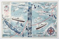
Misc vintage French travel poster and route map for the Messageries Maritimes shipping company, specifically highlighting its service between Tahiti, New Caledonia, and Australia.
AbeBooks
AbeBooks
+1
Created around 1950 by the artist Hervé Baille, the poster illustrates the "Pacific Ocean Line" routes serviced by the sister ships m.s. Caledonien and m.s. Tahitien.
Antique Print Map Room
Antique Print Map Room
+1
Historical Context & Features
The Vessels: Both ships were passenger-cargo liners launched in the early 1950s—the Caledonien in 1952 and the Tahitien in 1953. They were among the last major ships of their kind to operate long-haul voyages before being largely replaced by jet air travel in the 1960s.
The Route: These ships operated on one of the world's longest maritime lines, traveling from Marseille, France, through the Panama Canal, and across the Pacific to Sydney, Australia. A full round trip could take nearly four months.
Artistic Elements: The map features a whimsical "pictorial" style characteristic of Hervé Baille. It includes:
Vignettes of island life, palm trees, and local people.
Mythical sea creatures, including mermaids, a trident-wielding Neptune figure, and various marine life like an octopus and shark.
A decorative compass rose in the bottom right and the Messageries Maritimes logo (a unicorn on a crowned anchor) in the top left.
Wikipedia
Wikipedia
+5
Key Locations on the Map
Nouvelle Calédonie (New Caledonia): Shown prominently on the left with its capital, Nouméa.
Polynesian Islands: The right side highlights islands like Tahiti (with its capital Papeete), Bora Bora, and Moorea.
Shipping Lines: The red line traces the nautical route connecting these far-flung French territories with Australia.
|
|
|
