 |
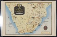
Half sheet This is a vintage 1947 pictorial "Map of The Royal Tour in South Africa," illustrated by Geographia Ltd. and published by the UK newspaper The Daily Telegraph.
Historical Context
The map chronicles the highly publicized, exhausting three-month official progress undertaken from February to April 1947 by the British Royal Family:
• King George VI
• Queen Elizabeth (the Queen Mother)
• Princess Elizabeth (the future Queen Elizabeth II, who celebrated her 21st birthday during this trip)
• Princess Margaret
The itinerary was designed as a massive goodwill tour to thank South Africa for its vital support during World War II, reinforce ties with the British Empire, and bolster the political position of South African Prime Minister Jan Smuts.
Key Map Features
• The Route: The bold red lines stretching across the subcontinent trace the precise track of the dedicated royal white train, commercial aircraft flights, and motor convoys. It covers a grand circuit starting from Cape Town, running through Pretoria, Johannesburg, Bloemfontein, and Durban, and extending as far north as Southern Rhodesia (now Zimbabwe) to visit Victoria Falls.
• Pictorial Vignettes: The map is heavily decorated with illustrations of indigenous African wildlife (elephants, lions, giraffes, springbok), geographic landmarks, sailing ships, and historical annotations marking local industries and milestones along the way.
• The Cartouche: The top left corner features an elaborate dark scroll containing the map title crowned by the British Royal Coat of Arms. |
|
|