 |
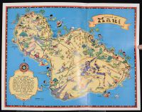
Small 1931 pictorial map of the Island of Maui.Map Details & History This whimsical "cartograph" was illustrated by the famed American artist and pictorial mapmaker Ruth Taylor White. In 1930, she traveled to Hawaii and was commissioned by the Hawaii Tourist Bureau to design a decorative series covering the Hawaiian islands. These maps were printed by the Honolulu Star-Bulletin and given out as souvenirs to tourists.Styling: Bold, vibrant colors with humorous, cartoonish characters representing local industries, sports, agriculture, and culture.Notable Landmarks Shown: The map highlights major spots like Kahului Harbor, Haleakal? Crater, Lahaina, taro patches, pineapple fields, and large sugar plantations.The Inset Cartouche: The decorative scroll in the bottom-left corner features White's personal dedication: "This Cartograph is lined and colored to memories of the good times I found on the Island of Maui...". |
|
|
