 |
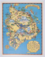
Small vintage "Cartograph of the Island of Hawaii". It is a whimsical, illustrated tourism map created by American artist Ruth Taylor White in 1930–1931 for the Hawaii Tourist Bureau.Map Details & Content Artistic Style: Known for its vibrant colors, humorous text snippets, and playful character sketches representing local life and activities.Geographical Landmarks: The map vividly details the island's three massive volcanic peaks: Mauna Kea, Mauna Loa, and Kilauea.Historical References: It notes crucial local history, including the birthplace of King Kamehameha I and the 1779 arrival/monument of Captain James Cook at Kealakekua Bay.The Cartograph Text: In the bottom-right corner, a decorative scroll reads: "A Cartograph that's drawn to my days and nights of adventure in the Island of Hawaii. It is called by some the 'Big Island,' by others, the 'Scenic Isle'...". |
|
|
