 |
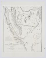
Small This document is the historic 1848 "Map of Oregon and Upper California". It was drawn by cartographer Charles Preuss based on the foundational western expeditions of John Charles Frémont.Key Details & Historical Significance Creation & Context: Commissioned by the United States Senate and published in Washington City in 1848, this landmark map captured the American West right at the close of the Mexican-American War.Territorial Changes: It provides one of the first official cartographic looks at the newly established Territory of Oregon and the shifting Mexican-United States borders.The Gold Rush: This specific map holds massive historic weight because it is one of the very earliest maps to identify and mark "El Dorado" or the Gold Region along the American and Plumas rivers, fueling the California Gold Rush.Geographical Features: It greatly expanded 19th-century knowledge of the Great Basin, the Sierra Nevada range, and the Sacramento and San Joaquin river valleys. It was also the first map to officially designate the entrance of the San Francisco Bay as the "Golden Gate". |
|
|
