 |
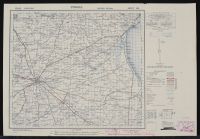
World War II-era military topographic map of
Foggia, Italy, produced by the U.S. Army Map Service (AMS).
Map Details
Series: This map belongs to the Italy 1:100,000 Series M691 (also known as GSGS 4164).
Sheet Information: It is Sheet 164, titled "Foggia".
Edition: This is the Second Edition, which was often updated using aerial photography to show the most current tactical information during the Allied invasion of Italy.
Scale: The scale is 1:100,000, meaning 1 unit on the map represents 100,000 units on the ground (e.g., 1 cm equals 1 km).
Production: The AMS was formed in 1942 to provide strategic maps for theaters of war in Europe and East Asia. These maps were frequently reproduced from original Italian Istituto Geografico Militare (IGM) surveys.
Key Features
Reference Legend: Located on the right, it provides a guide to topographic symbols such as roads, railroads, and boundaries.
Grid System: The map uses a military grid system based on the meridian of Rome, which is 12°27'7.1" east of Greenwich.
Tactical Context: Maps like this one were critical for the Allied Italian Campaign, specifically for the invasion that took place in September 1943. Foggia was a major strategic target due to its large airfield complex. |
|
|
