 |
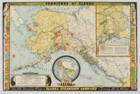
Map vintage 1936 "Territory of Alaska" advertising map created by Frank McCaffrey for the Alaska Steamship Company. The map is titled "The All-American Route" and was intended to promote tourism and the company's shipping services to the territory before it became a U.S. state in 1959.
Map Details and Features
Illustrator and Publisher: The map was illustrated and copyrighted in 1936 by Frank McCaffrey, who owned Seattle's Acme Press.
Purpose: It highlights the year-round and seasonal steamship routes, as well as connecting railroads and highways, from Seattle to various locations throughout the Territory of Alaska.
Design: The map is known for its colorful and pictorial style, featuring decorative borders with illustrations of totem poles, a grizzly bear, and a seal.
Insets: It includes two inset maps:
One details the area around Anchorage and the Prince William Sound region.
A second shows a broader view of North America, illustrating distances from major U.S. cities to Alaska, with Seattle as the central hub.
Information: Key facts about the territory are included, such as its square mileage (586,400), estimated population (62,000), purchase date from Russia (March 1867), and purchase price ($7,200,000).
Resources: Areas noted for natural resources like gold, copper, oil, and whaling are shaded on the map. |
|
|
