 |
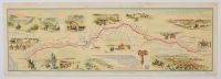
Folded paper display, map of the Pony Express route, which operated from April 1860 to October 1861.
The Pony Express was a mail service that used riders on horseback to deliver mail from St. Joseph, Missouri, to Sacramento, California.
The route was approximately 1,900 miles long and passed through eight states: Missouri, Kansas, Nebraska, Colorado, Wyoming, Utah, Nevada, and California.
Mail delivery took about 10 days, which was significantly faster than other services at the time.
The Pony Express was an important communication link between the East and West coasts of the United States before the completion of the transcontinental telegraph.
|
|
|
