
Road Map Of England
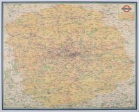 |
40 x 50, Royal Quad, antique map titled "London Transport All Routes Road & Rail.". It is a map of the London Passenger Transport Board (LPTB) operating area. This type of map was published by London Transport, with some versions dating back to as early as 1935. While some sources associate cartographer Benjamin Rees Davies with detailed London maps, his work is from a much earlier period, primarily the 19th century |