 |
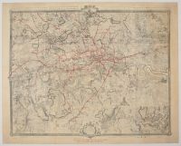
40 x 50, royal quad, John Rocque's Map of London
The map shown is an edition of "An Exact Survey of the City's of London, Westminster, ye Borough of Southwark and the Country Near Ten Miles Round" by John Rocque, which was originally published in 1746. The original map, engraved by John Pine, was a landmark in 18th-century cartography for its detail and accuracy, taking nearly a decade to complete.
The red lines overlaid on the map appear to represent the railway and London Underground network. This type of overlay is often used to show how the modern transit system developed in relation to the historic landscape of London. The original map itself does not contain any of these red lines, as it was created in the mid-1700s, long before the establishment of London's railway system. The inclusion of the red lines transforms the historic map into a visual representation of how the city evolved over time |
|
|
