 |
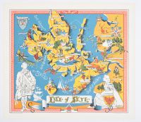
Small, This is a pictorial map of the Isle of Skye created by A. Macphee around 1960
. The map features humorous illustrations that highlight the local customs, history, and natural features of the island, including landmarks, wildlife, and characters. Some of the features depicted include:
Places: Portree, Dunvegan, Broadford, and Kyle of Lochalsh.
Historical and Cultural Elements: The Battles of Trumpan (1580) and Glenshiel (1719), Viking longships, and a bagpiper in a kilt.
Natural and Economic Features: The Talisker Whisky distillery, the Old Man of Storr rock formation, Highland cows, sheep, and fishing boats.
The map was published by John Bartholomew & Son Ltd. in Edinburgh. |
|
|
