 |
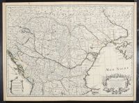
Map, cartography, "Carte de la Hongrie et des pays qui en dependoient autrefois"
This is an antique French map of Hungary and the surrounding regions, titled "Carte de la Hongrie et des pays qui en dependoient autrefois" (Map of Hungary and the countries that once depended on it). The map was created by the French cartographer Guillaume Delisle in 1703 and later reissued by Covens & Mortier.
The map depicts the Kingdom of Hungary and neighboring territories, including parts of modern-day Romania, Ukraine, Serbia, Macedonia, and Albania. It provides a detailed look at the political and geographical landscape of Central and Eastern Europe during the early 18th century. The map's details, such as boundaries, rivers, towns, and mountains, illustrate the territorial structure of the Austro-Hungarian Empire at that time. |
|
|
