
Boston Proper
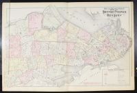 |
Blueprint, This map is an Outline and Index Map of Boston Proper and Roxbury. It is a historical map, with search results indicating it was published around 1890 by G.W. Bromley & Co. as part of their "Atlas of the City of Boston". The map includes street names, ward numbers, railroads, and other points of interest from that era. It is a significant resource for understanding the urban development of Boston during the late 19th century, particularly the areas of Boston Proper and Roxbury. |