You are not authorized to access that location.
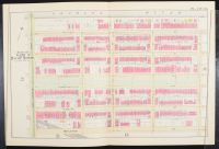 |
Blueprint, The image shows
Plate 13 from a historical atlas of Boston, Massachusetts. The map details a section of Ward 11, including the Charles River and several streets such as Beacon, Marlborough, Commonwealth, Newbury, and Boylston Streets. This particular plate is from an atlas created by G. W. Bromley & Co., with different versions dating from the late 19th and early 20th centuries, such as 1890, 1895, and 1902. The map is a hand-colored plan that shows property lines and building footprints in the Back Bay neighborhood of Boston.
This type of map is often referred to as a "plat map" or a "fire insurance map" and is a valuable resource for historical and architectural research |
|
|
