 |
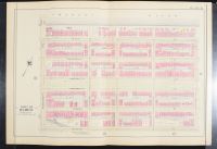
This image shows Plate 9 of the
Atlas of the City of Boston, which depicts a section of the city's Back Bay neighborhood. The map, likely published around 1895, shows the area between the Charles River and Boylston Street
, and between Massachusetts Avenue
and Exeter Street
. The streets visible on the map include Beacon Street
, Marlborough Street
, Commonwealth Avenue
, Newbury Street
, and Boylston Street
.
The Back Bay neighborhood was originally tidal flats that were filled in during the mid-19th century. This created a new, planned residential district known for its grid-like street layout and row houses, which was inspired by the design of Paris |
|
|
