 |
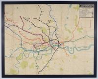
Tube map London Underground map from the early 1930s, likely the 1932 edition designed by Fred Stingemore or a transitional version just before Harry Beck's iconic design was fully adopted. It is one of the last geographically accurate maps before the system transitioned to the diagrammatic style used today.
Map Details
Designer: This style of geographically based map was developed by designers like Fred Stingemore. Harry Beck's revolutionary, circuit-diagram style map was introduced in 1933.
Style: The map retains topographical accuracy with some distortion, showing the winding routes and actual distances between stations, unlike the modern map that uses simplified straight lines and 45-degree angles.
Lines and Features: Many lines have names familiar today, such as the Bakerloo Line, Piccadilly Line, Central Line, and District Railway. The map from around 1932 specifically shows the Piccadilly Railway extensions.
Historical Significance: These pre-Beck maps were difficult to read in the crowded central London area due to the density of lines and stations. This challenge led Harry Beck, an electrical draughtsman, to propose his non-geographical, schematic diagram, which became an immediate success with the public in 1933 and is the basis of all subsequent maps. |
|
|
