You are not authorized to access that location.
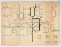 |
Original illustration of a
vintage London Underground map, designed in the iconic diagrammatic style created by Harry Beck. This design, first introduced in 1933, is renowned for its use of only straight lines and 45-degree angles, prioritizing clarity of connections and relative station positions over geographical accuracy. The specific map in the image appears to be from a mid-century era, likely the 1950s, given the coverage of the lines.
Key features of the map include:
Color-Coded Lines: Different colors represent the various Tube lines, such as the Bakerloo (red), Central (orange), Circle (yellow), District (green), Metropolitan (purple), Northern (black), and Piccadilly (light blue).
Schematic Layout: Stations are shown at evenly spaced intervals, with interchange stations indicated by diamond or circle symbols, making the complex network easy to navigate.
Focus on Function: The map's primary purpose is practical: to help passengers understand the network and their journeys, rather than showing distances to scale.
Design Classic: Harry Beck, an electrical draughtsman, developed this style in his spare time, basing it on electrical circuit diagrams. His innovative design has become a global standard for public transport maps |
|
|
