 |
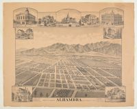
historical "bird's eye view" map of Alhambra
, a city in Los Angeles County, California, showing the area as it appeared in the late 1880s. These types of maps were popular in the late 19th century as a way to promote the development and settlement of new towns.
Map Details
Location: Alhambra, Los Angeles Co., California.
Date: Circa 1888, during a period of significant growth in the San Gabriel Valley.
Features: The map illustrates a developing town grid laid out over what appears to be extensive agricultural land, particularly orchards. The San Gabriel Mountains are visible in the background.
Vignettes: The border includes detailed illustrations of prominent local buildings and residences from that era, a common feature of panoramic maps.
Historical Context: Alhambra was founded as a subdivision of land owned by Benjamin Wilson and James De Barth Shorb. It was incorporated as a city in 1903. Many streets on these early maps, such as Atlantic Boulevard (originally Wilson Avenue), are still present today. |
|
|
