You are not authorized to access that location.
Map Of London
 |
40 x 50 royal quad "
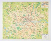
London & Suburbs Main Line Railways", is a vintage railway map published in 1956. It was produced by the British Transport Commission and printed by George Philip & Son Ltd..
The map details the British Railways lines within the area that roughly encompasses Greater London.
Key Features
Main Lines: Railway main lines are prominently shown in red.
Underground Lines: Underground services are indicated by black lines, helping to differentiate between the two systems.
Background Detail: The rail networks are superimposed over a more general geographic map that includes roads, parks (green areas), lakes, and the River Thames.
Style: Unlike modern, more schematic maps like Harry Beck's famous Tube map, this map is more geographically accurate, showing the actual layout of the lines in relation to the city's geography. |
|
|
