 |
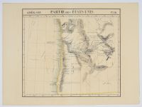
Map "
Partie des États Unis. Amer. Sep. No. 38." (Part of the United States, North America, No. 38), a historical map of the Washington and Oregon region, including the coastline. It was created by Belgian cartographer Philippe Marie Vandermaelen around 1825–1827.
Map Details
Cartographer: Philippe Marie Vandermaelen
Date: Circa 1825–1827
Area Depicted: The map focuses on the Pacific Northwest coast, specifically the areas that would become Washington and Oregon states.
Atlas: It was published as part of Vandermaelen's Atlas Universel, which was notable as the first lithographic atlas and the first to present all maps on the same scale.
Content: The map shows relief pictorially and by hachures, and includes details such as various Indigenous American tribes and populations, as well as the routes of explorers like Captain James Cook, George Vancouver, and Jean-François de La Pérouse. |
|
|
