You are not authorized to access that location.
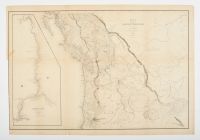 |
"Map of the Oregon Territory" produced by the U.S. Exploring Expedition (U.S. Ex. Ex.) under the command of Lieutenant Charles Wilkes. Though dated 1841, it was originally published in 1845 as part of the atlas accompanying Wilkes' official five-volume narrative of the expedition.
Map Details and Historical Context
Significance: It is considered the finest and most detailed American map of the Pacific Northwest published at the time and was crucial for bolstering U.S. claims to the region during boundary disputes with Great Britain.
Coverage: The map details the region stretching from the Pacific Coast to the Rocky Mountains, encompassing modern-day Oregon, Washington, Idaho, and parts of British Columbia, Montana, Wyoming, Utah, and northern California.
Surveys: The map incorporates the results of the first American surveys of the Columbia River and Puget Sound, as well as information from overland explorations by expedition members, Hudson's Bay Company traders, and other explorers like John C. Frémont and Jedediah Smith.
Inset: A large, detailed inset on the left side of the map focuses on the Columbia River, highlighting the treacherous river bar where one of the expedition's ships, the Peacock, was lost.
Boundary Dispute: Wilkes strongly advocated for the northern boundary of the Oregon Territory to be at the 54°40' parallel, a position that fueled the "54-40 or Fight!" political slogan during the 1844 U.S. presidential election. The final boundary was eventually set at the 49th parallel by treaty in 1846. |
|
|
