 |
40 x 50 royal quad
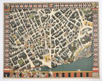
"Theatreland" map of London, a pictorial map created by the artist and cartographer MacDonald Gill in 1915. It was originally commissioned as a poster by the Underground Electric Railways Company to encourage travel to the West End theatres.
Key Details
Artist: Leslie MacDonald "Max" Gill (1884–1947).
Year: 1915.
Commissioned by: The Underground Electric Railways Company.
Style: The map uses an illustrative, "birds-eye-view" approach reminiscent of 17th-century cartography, filled with humorous details and caricatures of people and places.
Features:
The border of the map lists all the theatres in the district.
Buildings are depicted in black and grey, while surrounding details and characters are in color.
The bottom right corner features a clever illustration of the map being lifted like a curtain to reveal an orchestra and conductor.
In the top right, a German Zeppelin airship is shown, a historical reference to the air raids over London during World War I.
This poster was the first of seven decorative maps that MacDonald Gill designed for London Transport and became highly popular with the public. |
|
|
