 |
Antikbar Small
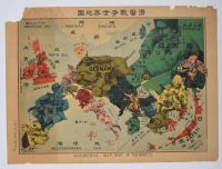
Japanese satirical broadsheet map published in September 1914 by Ry?z? Tanaka. Titled Kokkei Sensou Sekai Chizu in Japanese, and A Humorous War Map of the World (with "Humorous Wap Map of the World" also appearing) in English, it offers a Japanese perspective on the early stages of World War I.
Map Details
Dating: The map was created shortly after the outbreak of World War I in August 1914.
Representations: Countries are personified as various figures and caricatures:
Germany is a formidable figure in the center, advancing aggressively.
Russia is a large, somewhat disheveled figure to the east, being confronted.
Great Britain and France appear as allied figures to the west.
Japan is depicted as a soldier, ready for battle near its home islands in the Pacific Ocean.
Propaganda: These types of "serio-comic" or "anthropomorphic" maps were a popular form of propaganda during the era, intended to communicate complex political situations to the public in an engaging, visual way. The map reflects Japan's alignment with the Allied powers (specifically England) during the conflict. |
|
|
