 |
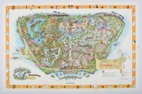
Attraction size, folded map vintage 1958 souvenir map of Disneyland, drawn by Imagineer Sam McKim. This map was the first year that such detailed pictorial maps were sold to the public in the park and through mail order.
Map Details
Year of Publication: The map has a 1958 copyright date. There are several slightly different versions (A, B, C) that were updated throughout the year to reflect the park's constant changes, such as forthcoming attractions for the 1959 season, including the Matterhorn Bobsleds and the Monorail.
Designer: The map was created by Disney Imagineer Sam McKim. He was responsible for a series of these "Fun Maps" from 1958 to 1964.
Features: The colorful map provides a bird's-eye view of the five original lands: Main Street, U.S.A., Adventureland, Frontierland, Fantasyland, and Tomorrowland.
"Lost" Land: The map prominently features "Holidayland" on the western side of the park (left side of the image), a separate picnic area and playground which was considered a "lost" land after it closed in 1961 to make way for New Orleans Square.
Collectibility: Original copies of these maps are considered significant artifacts in Disney history and are highly collectible, with original versions sometimes fetching thousands of dollars at auction. Reproductions are also widely available for purchase. |
|
|
