 |
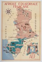
One sheet
vintage pictorial map of French Equatorial Africa (Afrique Équatoriale Française or AEF), created around 1950 by the artist J. Choain Audiberti.
Map Details
Artist and Date: The map was designed by J. Choain Audiberti and published around 1950. Other sources mention the artist Leon Craste, and a publication date of 1951 for a similar map published by the Ministère de la France d'Outre-Mer.
Colonial Territories: It depicts the former French colonial federation, including the territories of Tchad (Chad), Oubangui-Chari (Central African Republic), Moyen-Congo (Republic of the Congo), and Gabon, alongside the French mandate territory of Cameroun (Cameroon).
Illustrative Style: The map uses a decorative and informative style, featuring vibrant illustrations of local people, wildlife (elephants, camels, antelopes), agriculture, and natural resources to promote travel and the region's economic themes.
Historical Context: These maps were produced during the twilight of the French colonial empire and represent the colonial-era perspective of the region. |
|
|
