 |
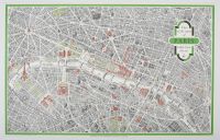
One sheet vintage, detailed,
bird's-eye-view map of the center of Paris. It was published by Éditions Blondel la Rougery (a French cartographic studio) for the French Government Tourist Office in the late 1950s, typically cited as 1958 or 1959.
The map is notable for blending technical accuracy with artistic flair. Key features include:
Detailed Streets: Nearly all streets and boulevards are named, offering a comprehensive guide to the city's layout.
Color-Coding: Important monuments and landmarks, such as the Eiffel Tower, the Louvre, and Notre Dame, are highlighted in red tones. Green spaces like the Tuileries Garden and major boulevards are colored green.
Unique Perspective: The "taken from the air" perspective provides a unique 3D-like orientation of the city's center. |
|
|
