 |
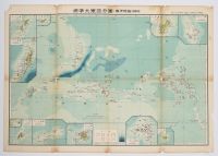
Japanese map from 1943 titled Standard Sectional Map of the Greater East Asia: the South Sea Islands (Inner South Sea). It was published during World War II and focuses on the Micronesia region, which Japan administered under a League of Nations mandate known as the South Seas Mandate (Nanyo Gunto) from 1914 to 1945.
Map Details
Title: Hyojun Daito-A bunzu: Nanyo gunto (nai Nanyo)
Publisher: T?seisha
Publication Year: Sh?wa 18, which corresponds to 1943
Cartographer: Keigo Serizawa
Content: The map details the Mariana Islands, Eastern and Western Caroline Islands, Marshall Islands, and Gilbert Islands. Inset maps around the main chart provide close-up views of specific islands, including Jaluit Atoll, Guam, Rota, Saipan, Palau, Yap, and Truk Islands. |
|
|
