 |
Map vintage
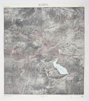
photo mosaic map of Kabul, Afghanistan.
Map Characteristics
Format: A "Photo Mosaic" which combines multiple aerial photographs to create a single, continuous top-down view of the city.
Key Features:
The city's major road networks are highlighted with red lines overlaying the aerial imagery.
Geographical landmarks like the Kabul River and surrounding mountainous terrain are clearly visible in high-contrast black and white.
Dense urban areas and formal city planning grids can be seen in the center and western parts of the city.
Contextual Significance
Such maps were often produced for urban planning, military, or diplomatic purposes during the mid-20th century. Similar aerial surveys and declassified satellite imagery (like those from the KH-4 or KH-7 programs) were used to document the growth of cities like Yekaterinburg or Orenburg during the 1960s and 70s. These photo mosaics provided a more detailed look at urban infrastructure compared to traditional drawn maps. |
|
|
