 |
One sheet vintage
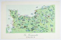
pictorial travel poster of Normandy, France, titled "La Normandie". It was designed by the French illustrator and poster artist Rémy Hétreau and published in 1955.
The map was commissioned by the French Ministry of Public Works, Transport, and Tourism. It features a vibrant, mid-century illustration style that highlights several key elements of the region:
Historical Landmarks: Includes depictions of numerous churches, castles, and chateaus.
Military History: Notable sites from the Normandy Invasion of WWII, specifically identifying Omaha and Utah beaches.
Cultural Figures: The map is populated with historical and modern figures, including a depiction of St. George and the dragon above Mont St. Michel.
Local Geography: Shows major towns such as Alençon, Cherbourg, and Rouen, along with hills and trees representing the "green vistas" of the region.
Original lithograph posters typically measure approximately 25.5 x 39 inches (65 x 100 cm). |
|
|
