 |
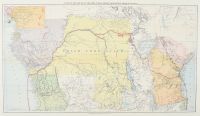
Map "A Map of the Route of the Emin Pasha Relief Expedition Through Africa," originally published in 1890.
This map illustrates the path of the last major European private expedition into the interior of Africa, which took place from 1886 to 1889. Led by explorer Henry Morton Stanley, the mission's primary goal was to rescue Emin Pasha, the Governor of Equatoria, who had been cut off by the Mahdist uprising in Sudan.
Key Map Details
Publisher: Charles Scribner's Sons, New York.
Geography: The map prominently features the Congo Free State and highlights the expedition's route along the Congo River and across Central Africa, eventually reaching the Indian Ocean.
Historical Context: It was originally included in Stanley's two-volume account of the journey, titled In Darkest Africa.
Cartography: The map reflects the European understanding of the region during the late 19th-century colonial era, showing established boundaries of the time, such as the "Free Trade Area". |
|
|
