 |
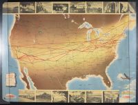
Half sheet double sided vintage Trans World Airlines (TWA) "Air Routes" map of the United States, dating to 1948.
This specific map is a celebrated example of post-WWII pictorial cartography, designed to promote TWA’s domestic and international connectivity during the "Golden Age" of aviation.
Key Features of the Map
The Red Lines: These bold red lines represent TWA’s primary flight routes, which spanned the country "coast to coast". Thinner black lines indicate connecting flights from other airlines.
Visual Border: The map is framed by a border of black-and-white photographs showcasing famous American landmarks and destinations, such as the Capitol Building, highlighting the accessibility of tourism via TWA.
The Aircraft: The bottom-right corner features an illustration of a Lockheed Constellation (often called the "Connie"), which was TWA's flagship four-engine aircraft and a mainstay of their fleet throughout the 1940s and 50s.
Design Context: Produced by TWA in 1948, these maps were often given as souvenirs to passengers or used in travel brochures to showcase the airline's expanding network after it officially adopted the name "Trans World Airline". |
|
|
