 |
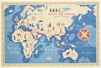
Halfsheet vintage 1949 pictorial map titled "B.O.A.C. World Air Routes: Eastern Hemisphere". It was illustrated by artist E.O. Seymour and published for the British Overseas Airways Corporation (B.O.A.C.).
The map is famously double-sided; while this side focuses on the Eastern Hemisphere, the reverse typically features the Western Hemisphere.
Key Historical Features
Aviation Network: Red and black lines represent the extensive postwar global network of B.O.A.C. and its affiliate airlines.
Pictorial Illustrations: The map is adorned with colorful vignettes depicting indigenous peoples, local wildlife, and iconic landmarks like Neuschwanstein Castle and various temples.
The "Speedbird": The iconic B.O.A.C. logo, known as the "Speedbird," is incorporated into the title block and the center of the large compass rose.
Post-War Unified World: Notably, national borders are omitted, presenting a world unified by the connectivity of air travel.
Original Specifications
Artist: E.O. Seymour
Printer: McCorquodale & Co., Ltd.
Medium: Color lithograph |
|
|
