 |
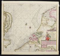
Map by Pieter Goss, A Dutch Hand Colored Copper Engraved Sea Chart Pascaart Van De Noord Zee 17th Century cartouche inscribed Pascaart van de Noord Zee van Texel tot de Hoofden. Nieulycx/'t Amsterdam Bij Pieter Goos. 23.25 x25 in. M
Sea chart of the English Channel, and west European coast, including Norway.
Additions on top and bottom edges comprised of paper approx 1.25 inches. Object appears to have been removed from a book the paper "stubb in" mostly intact along central vertical fold line. |
| Remove from frame, dehinge, examine and document.
Recommend no interventions. |
|
