
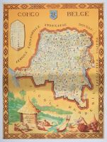
Congo Belge
Antikbar one sheet
vintage pictorial map of the Belgian Congo (Congo Belge). The original poster was designed by the Belgian illustrator Frans Laboulais (1903-1988) and published around 1949.
Map Details
Illustrator: Frans Laboulais
Publication Date: circa 1949
Publisher: The original map was likely commissioned for the Belgian Congo and Ruanda-Urundi Information and Tourism Office or other Belgian entities to promote the colony.
Content: The map is a travel poster that utilizes illustrations to highlight the region's natural resources, fauna (elephants, giraffes), major cities (Léopoldville, Elisabethville), and local populations, reflecting a mid-century colonial aesthetic meant to entice tourists.
Borders: The outer borders are decorated with a pattern, and the map itself features illustrations of traditional Congolese art and objects along the bottom and right sides, with a corresponding bilingual legend in French and Dutch.
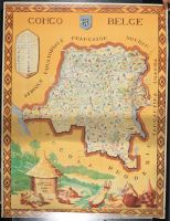
Mounted
Disclaimer
The object and/or subject of this report is private property. This page is for informational purposes only. Unless clearly stated otherwise, all conservation and restoration has been performed by Poster Mountain (PM) or Los Angeles Paper Group (LAPG)I) PM-LAPG has not knowingly withheld any significant information from its evaluation report and to the best of its knowledge all statements and evaluations in this report are true and correct.
II) PM-LAPG stated in the Evaluation Report its own personal, unbiased and professional analysis, opinions and conclusions, which are subject to the assumptions and limited conditions in this evaluation report as set forth hereinabove.
III) PM-LAPG has no present or prospective interests in the property which is the subject matter of this report and it has no present or prospective personal interests or bias with respect to the participants in this matter.
IV) PM-LAPG and its employment and/or compensation for performing this evaluation or any future anticipated evaluation was not conditioned on any agreement or understanding, written or otherwise, that it would report (or present analysis in support) as predetermined specific authenticity, a predetermined evaluation that favors the cause of any party or the attainment of any specific result or occurrence of a specific subsequent event, such as value or marketability.
V) PM-LAPG prepared all opinions and conclusions about the subject property that were set forth in this Evaluation Report. If it has relied on significant evaluation assistance from any individual or individuals in the performance of this evaluation or the appropriation of this evaluation report, PM-LAPG has named such individuals and disclosed the specific task performed in this evaluation report. PM-LAPG certifies that any individual so named is qualified to the same extent as PM to perform the task. PM-LAPG has not authorized anyone to make a change to any item in this evaluation report, therefore, any change made to this evaluation is unauthorized and PM-LAPG will not take responsibility for it.
VI) The Client may not disclose or distribute this Evaluation Report to any potential purchasers of the subject property without first obtaining PM-LAPG's prior written consent. This consent must be obtained before this evaluation report may be disclosed or distributed to any other party, including, but not limited to, the public through advertising, public relations, news, sales, or other media.