
Rock Island
Misc map "
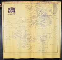
Rock Island: Lines Removed or Sold Since January 1, 1936," is a historical document dated January 1974 that tracks the contraction of the Chicago, Rock Island and Pacific Railroad (CRI&P).
The map uses specific line styles to visualize the railroad's decline:
Solid Bold Lines: Represent the active network still operated by the Rock Island as of 1974.
Dashed or Dotted Lines: Indicate rail segments that were abandoned, removed, or sold to other carriers between 1936 and 1974.
Historical Significance
Era of Decline: By 1974, the Rock Island was in severe financial distress, often referred to as being in "bankruptcy blue" due to its final locomotive paint scheme.
Pruning the Network: The "removed or sold" lines on this map highlight the railroad's attempts to "slim down" by abandoning unprofitable agricultural branch lines and secondary routes to save costs.
Liquidated Status: Just six years after this map was printed, the entire railroad was ordered to be liquidated and shut down in 1980, marking one of the largest bankruptcy liquidations in U.S. history.
Successor Roads: Many of the lines shown as "sold" or eventually liquidated were acquired by rivals like Union Pacific, Southern Pacific, and the Burlington Northern.
Disclaimer
The object and/or subject of this report is private property. This page is for informational purposes only. Unless clearly stated otherwise, all conservation and restoration has been performed by Poster Mountain (PM) or Los Angeles Paper Group (LAPG)I) PM-LAPG has not knowingly withheld any significant information from its evaluation report and to the best of its knowledge all statements and evaluations in this report are true and correct.
II) PM-LAPG stated in the Evaluation Report its own personal, unbiased and professional analysis, opinions and conclusions, which are subject to the assumptions and limited conditions in this evaluation report as set forth hereinabove.
III) PM-LAPG has no present or prospective interests in the property which is the subject matter of this report and it has no present or prospective personal interests or bias with respect to the participants in this matter.
IV) PM-LAPG and its employment and/or compensation for performing this evaluation or any future anticipated evaluation was not conditioned on any agreement or understanding, written or otherwise, that it would report (or present analysis in support) as predetermined specific authenticity, a predetermined evaluation that favors the cause of any party or the attainment of any specific result or occurrence of a specific subsequent event, such as value or marketability.
V) PM-LAPG prepared all opinions and conclusions about the subject property that were set forth in this Evaluation Report. If it has relied on significant evaluation assistance from any individual or individuals in the performance of this evaluation or the appropriation of this evaluation report, PM-LAPG has named such individuals and disclosed the specific task performed in this evaluation report. PM-LAPG certifies that any individual so named is qualified to the same extent as PM to perform the task. PM-LAPG has not authorized anyone to make a change to any item in this evaluation report, therefore, any change made to this evaluation is unauthorized and PM-LAPG will not take responsibility for it.
VI) The Client may not disclose or distribute this Evaluation Report to any potential purchasers of the subject property without first obtaining PM-LAPG's prior written consent. This consent must be obtained before this evaluation report may be disclosed or distributed to any other party, including, but not limited to, the public through advertising, public relations, news, sales, or other media.