
Blue Print Pan AM
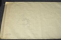
Misc. Pan AM large vintage Northern Route Plotting Sheet for a journey between Botwood and Foynes (the Western Section).Historical SignificanceThe Route: This map highlights a critical early transatlantic aviation path used during the mid-20th century. Botwood, Newfoundland, and Foynes, Ireland, were major terminals for flying boats (seaplanes) like the Pan Am Clippers and BOAC flying boats before long-range land-based aircraft became standard.Botwood: Visible on the left side of the map, it served as a key refueling and takeoff point for flights heading across the Atlantic from North America.Plotting Sheet Details: These maps were essential for navigators to track their position using dead reckoning and celestial navigation over the vast, featureless ocean. It includes detailed latitude and longitude grids, compass roses for orientation, and coastal outlines for visual reference at the start and end of the crossing.Comparable Historical MapsIf you are interested in similar historical nautical or aeronautical charts, you may find these examples relevant:1857 US Coast Survey Maps: Early technical surveys showing the progress of coastal mapping.World War II Japanese Navy Charts: Detailed aeronautical maps used for strategic planning in the Pacific, such as around Hawaii.British Admiralty Charts: Standardized nautical charts produced by the UK Hydrographic Office for over 200 years.

Disclaimer
The object and/or subject of this report is private property. This page is for informational purposes only. Unless clearly stated otherwise, all conservation and restoration has been performed by Poster Mountain (PM) or Los Angeles Paper Group (LAPG)I) PM-LAPG has not knowingly withheld any significant information from its evaluation report and to the best of its knowledge all statements and evaluations in this report are true and correct.
II) PM-LAPG stated in the Evaluation Report its own personal, unbiased and professional analysis, opinions and conclusions, which are subject to the assumptions and limited conditions in this evaluation report as set forth hereinabove.
III) PM-LAPG has no present or prospective interests in the property which is the subject matter of this report and it has no present or prospective personal interests or bias with respect to the participants in this matter.
IV) PM-LAPG and its employment and/or compensation for performing this evaluation or any future anticipated evaluation was not conditioned on any agreement or understanding, written or otherwise, that it would report (or present analysis in support) as predetermined specific authenticity, a predetermined evaluation that favors the cause of any party or the attainment of any specific result or occurrence of a specific subsequent event, such as value or marketability.
V) PM-LAPG prepared all opinions and conclusions about the subject property that were set forth in this Evaluation Report. If it has relied on significant evaluation assistance from any individual or individuals in the performance of this evaluation or the appropriation of this evaluation report, PM-LAPG has named such individuals and disclosed the specific task performed in this evaluation report. PM-LAPG certifies that any individual so named is qualified to the same extent as PM to perform the task. PM-LAPG has not authorized anyone to make a change to any item in this evaluation report, therefore, any change made to this evaluation is unauthorized and PM-LAPG will not take responsibility for it.
VI) The Client may not disclose or distribute this Evaluation Report to any potential purchasers of the subject property without first obtaining PM-LAPG's prior written consent. This consent must be obtained before this evaluation report may be disclosed or distributed to any other party, including, but not limited to, the public through advertising, public relations, news, sales, or other media.