
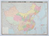
Map Of China
One sheet
political and administrative map of the People's Republic of China, showing provincial boundaries, major cities, and geographic features in both English and Chinese languages. It was likely published by the China Cartographic Publishing House (Zhongguo di tu chu ban she), also known as SinoMaps Press, which is the only national-level map publisher in China.
Map Details and Features
Title: Map of the People's Republic of China (MAP OF THE PEOPLE'S REPUBLIC OF CHINA).
Publisher: China Cartographic Publishing House / SinoMaps Press (Zhongguo di tu chu ban she;.
Content: The map provides a general view of the country's basic aspects, including:
Administrative divisions (provinces, autonomous regions, municipalities, and special administrative regions).
International and provincial boundaries.
Location of the national capital (Beijing) and provincial capitals.
Major cities, railways, and highways.
Water features, deserts, and the Great Wall.
Scale: Similar maps published by SinoMaps Press often use a scale of 1:6,000,000.
Language: The map is bilingual, featuring both English and Simplified Chinese characters.
Features: Standard map elements such as a legend (key), scale bar, north arrow, and an inset map (likely showing the South China Sea islands) are typically included
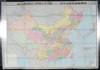
Mounted
Disclaimer
The object and/or subject of this report is private property. This page is for informational purposes only. Unless clearly stated otherwise, all conservation and restoration has been performed by Poster Mountain (PM) or Los Angeles Paper Group (LAPG)I) PM-LAPG has not knowingly withheld any significant information from its evaluation report and to the best of its knowledge all statements and evaluations in this report are true and correct.
II) PM-LAPG stated in the Evaluation Report its own personal, unbiased and professional analysis, opinions and conclusions, which are subject to the assumptions and limited conditions in this evaluation report as set forth hereinabove.
III) PM-LAPG has no present or prospective interests in the property which is the subject matter of this report and it has no present or prospective personal interests or bias with respect to the participants in this matter.
IV) PM-LAPG and its employment and/or compensation for performing this evaluation or any future anticipated evaluation was not conditioned on any agreement or understanding, written or otherwise, that it would report (or present analysis in support) as predetermined specific authenticity, a predetermined evaluation that favors the cause of any party or the attainment of any specific result or occurrence of a specific subsequent event, such as value or marketability.
V) PM-LAPG prepared all opinions and conclusions about the subject property that were set forth in this Evaluation Report. If it has relied on significant evaluation assistance from any individual or individuals in the performance of this evaluation or the appropriation of this evaluation report, PM-LAPG has named such individuals and disclosed the specific task performed in this evaluation report. PM-LAPG certifies that any individual so named is qualified to the same extent as PM to perform the task. PM-LAPG has not authorized anyone to make a change to any item in this evaluation report, therefore, any change made to this evaluation is unauthorized and PM-LAPG will not take responsibility for it.
VI) The Client may not disclose or distribute this Evaluation Report to any potential purchasers of the subject property without first obtaining PM-LAPG's prior written consent. This consent must be obtained before this evaluation report may be disclosed or distributed to any other party, including, but not limited to, the public through advertising, public relations, news, sales, or other media.